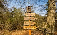
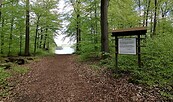
Circular trail through the Briesetal

Hiking tours
Length: 7 km
0 Ratings of 5 (0)
0
0
0
0
0
How did you like your stay? You have already rated your stay.
Length: 7 km
From €
Show availability & price

p.P. = pro Person, p.P./N = pro Person / Nacht, p.E./N = pro Einheit/ Nacht, EZ = Einzelzimmer, DZ = Doppelzimmer, FeWo = Holiday flats /home, App. = Appartement, Suite = Suite, FR = Frühstück, HP = Halbpension, VP = VollPension
The Briesetal Valley is near the north city boundary of Berlin. Here, the Bach Briese stream winds its way from Lake Wandlitzsee to the River Havel.
Continue readingcollapse
  • Briesetal, Foto: TMB-Fotoarchiv/Steffen Lehmann
  • Briesetal, Foto: TMB-Fotoarchiv/Steffen Lehmann
  • Briesetal, Foto: TMB-Fotoarchiv/Steffen Lehmann
  • Briesetal, Foto: TMB-Fotoarchiv/Steffen Lehmann
  • Briesetal, Foto: FRED & OTTO
  • Briesetal, Foto: TMB-Fotoarchiv/Steffen Lehmann
The course of the stream is at its most magical in the Briesetal Valley. From Wensickendorf Forester’s House to the source of the River Else, the brook valley provides an almost primeval view of the forest.

Length: 11 kilometres (3-4 hours)

Start/finish: The Schlagbrücke Bridge between Oranienburg and Summt, in the middle of the Briesetal Valley.

How to get there: 
  • Car: Leave Berlin via the A114 and the A10 North Berlin Ring in the direction of Oranienburg/Hamburg/Rostock. From the Mühlenbeck junction, you continue on through and via the L211 to the Schlagbrücke Bridge.
  • Parking: Schlagbrücke Bridge parking area


Route: Schlagbrücke Bridge parking area, Wensickendorf Forester’s House, Schlagbrücke Bridge, source of the River Else, Schlagbrücke Bridge parking area

Route description:

From the Schlagbrücke Bridge, the tour runs along both banks of the River Briese to Wensickendorf Forester’s House and to the source of the River Else

You can also cross the Briesetal Valley with your dog. Apart from some road traffic at the beginning of the tour, there is nothing more to interrupt a quiet, stress-free hike with your dog. During the hottest time of the year, the hiking trails can be quite busy at weekends.

Tour combinations:

  • Fourth Stage of the 66 – Lakes – Hiking Tail


 Trail conditions/surface: not specified

Tour information:

Maps: KOMPASS Wanderkarte Rheinsberger Seengebiet, Ruppiner Seenland: 4in1 Wanderkarte 1:50000 (Nr.743) ISBN-13: 978-3990443927 Euro 11.99
Continue readingcollapse

Arrival planner

an der L 211

16547 Summt

Weather Today, 2. 8.

17 23
scattered clouds

  • Sunday
    14 17
  • Monday
    12 23

Brochures

Holiday region

Tourismusverband Ruppiner Seenland e. V.

Fischbänkenstraße 8
16816 Neuruppin

Tel.: +49 (0) 3391-659630
Fax: +49 (0) 3391-659632

Weather Today, 2. 8.

17 23
scattered clouds

  • Sunday
    14 17
  • Monday
    12 23

Alle Informationen, Zeiten und Preise werden regelmäßig geprüft und aktualisiert. Trotzdem können wir für die Richtigkeit der Daten keine Gewähr übernehmen. Wir empfehlen Ihnen, vor Ihrem Besuch telefonisch / per E-Mail oder über die Internetseiten des Anbieters den aktuellen Stand zu erfragen.